Sunday, June 22, 2014

College Roommate

After spending a couple of days with my mother in St. Charles, MO we drove to Newburgh, IN where we spent Saturday and Sunday morning with my college roommate Colleen and her husband Dave.  I had seen Colleen last about 10 years ago when she joined my girls ski group out in Breckinridge, CO.  We had such a great visit.  I don’t think Colleen has change any through the years.  They live right on the magnificent Ohio River and within walking distance of historic downtown Newburgh (outside of Evansville).  This town was established in the late 1700 and was a major stop on the Ohio River between Cincinnati and New Orleans.

IMG 1270

We left Colleen and Dave and drove to Bardstown, Kentucky, the second oldest town in Kentucky, the home of Stephen Foster (My Old Kentucky Home) and - this is the important thing - the center of Bourbon country!

Saturday, June 21, 2014

Home and Gone Again

I was so excited to arrive at our daughters home in Norman, OK and play with our grandsons that I completely stopped writing. We enjoyed the Easter weekend with our family and arrived home April 21. 

 
We spent Labor Day Weekend camping with RJ and Erin's families on Beaver Lake, Arkansas then a week camping with our 8-year old grandson in Branson, Bull Shoals and Petit JeanState Park.
 
We are now on the road for our summer adventure. Our plans are really loose at this ime. We know we will be in the Upper Peninsula of Michigan mid-July, Oshkosh last week of July and at Mayo Clinic in Rochester, MN on August 4. After that is a big question mark. 
 

Wednesday, April 16, 2014

Middle of No-Where

We thought it might be fun to travel cross-country from Albuquerque to Norman, OK. but first we stopped  to get some minor repairs made on the RV while in Albuquerque.  Then on Monday night we stayed in the Sumner Lake State Park near Fort Sumner, NM.  This is where Billy The Kid called home and his real grave is here.

Tuesday we drove cross country into the panhandle of Texas and camped in Caprock Canyons State Park.  The drive was hard due to a southern cross wind and two lane roads plus the scenery was all prairie, fields of new wheat and more stock yards than I ever want to smell!

It dawned on me today that the theme of this winter trip has been canyons — Anza-Borego canyons in CA, Zion & Bryce Canyons in UT and now Texas.  This area is considered a transitional eco-zone as we are transitioning from high, flat plains to the rolling hills of Texas and this area is full of red-rock canyons, bison, prairie dogs and scrub brush.

P1000866

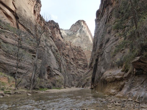
We were pretty lazy today and didn’t go on our hike until late afternoon then we walked a little over 3 miles in the bottom of Prong Canyon. These are certainly not as magnificent as Bryce’s red rock walls, but they are impressive non the less.

Sunday, April 13, 2014

SNOW in April !?!

Yes, this morning we awoke to find snow on the ground and still coming down!  It wasn’t that much but it did reinforce our decision to head back south and eastward as we start our last leg of this winter adventure.

Because of the snow and then rain it took us a little longer to get moving. The views as we traveled east under the Escalante Staircase and past the Vermillion Cliffs and Monument Valley was very pretty.  The bad part is that it threatened rain almost all day and the winds were terrible.  Most of the time they came at us from the north side but sometimes we were positioned so that they pushed us.  The roads were not always very smooth, sometimes they were narrow or under construction and combined with the wind it made for a long and exhausting drive. 

We found a closed weigh station north of Albuquerque to stop at for the night.

Saturday, April 12, 2014

Many More Canyons

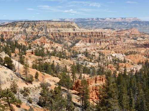
Bryce Canyon is not just one canyon but a series of canyons along a 40 mile stretch of the Paunsaugunt Plateau on the west side the park.  Then all along its eastern rim the Paria River has aided in the erosion and sculpting of the rock along with rain, wind, freezing and thawing waters.

P1000851

P1000857

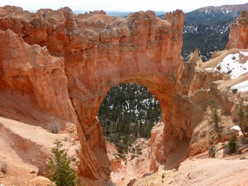
Today’s exploration took us south along the park road for 18 miles where we stopped at numerous vista points to see more of the parks features.  Swamp Canyon, Farview Point, Natural Bridge, Agua Canyon, Ponderosa Canyon, and Rainbow Point are just some of the stops.   The further south we went, the more elevation we gained and so more snow was still on the ground at Rainbow Point where we walked a mile loop to take in different vantage points of the same hoodoos and canyon walls. If we had more energy and stamina we could have hiked some of the longer trails at the bottom of the canyons or on the under-the-rim trails.

P1000859

P1000860

The far-off views were fairly hazy but I could swear we could see the Grand Canyon (but John says I’m directionally challenged and there is no way I could see that far). 

Friday, April 11, 2014

London Bridges Falling Down?

I’m just being silly but our hike today did take us to the Tower Bridge which reminded me of the London Tower Bridge.

We chose this hike for the distance more than anything.  It is part of the Fairyland Loop trail which is 8 miles long but we didn’t think we could handle that so this 3.4 mile down and back was just perfect.  And it was down to the bottom and then back up to the top (about an 800 foot elevation change).  But at the bottom we found the Tower Bridge rock formation and a quiet area among some trees with a gurgling creek and a Stellar Jay happily serenading us.

P1000846

It was fun walking around many hoodoos, looking up at them towering over us or finding whimsical shapes like simple mushrooms or a DQ ice cream cone and more elaborate ones that reminded me of castles in the air or fairy land abodes.

Later in the day we drove east from the park to check out some local communities and we drove through more hoodoos and red cliffs.  It is so pretty here!  Our evenings are spent around a roaring campfire listening to children playing and the birds giving us one last song before they go to bed. 

Thursday, April 10, 2014

Bryce Canyon National Park

We got up and got going early this morning to drive the 2 1/2 hours from Zion to Bryce.  And boy what a difference experience this will be compared to Zion.

First, the weather is much cooler here as we are at almost 9,000 foot elevation.  According to the rangers it is still winter in Bryce until mid-May, it could still snow!  John checked the weather channel app and we will get really cold in a couple of nights!

Second, because it is still ‘winter’ not many services are open or available.  Only one of the two campgrounds is open and then they are using only 2 of the 5 loops.  We are certainly glad we got here early in the day because all the campsites were full by late afternoon!  The shuttle buses won’t start running until Memorial weekend, the lodge is still closed, several places in the nearby town are still closed and the dump station is closed.

P1000832

P1000824

P1000826

Third, we are on top of the mesa and plateaus where we are camped in the pine trees while the drives and walks will look down on the eroded and sculpted canyon walls rather than up the sheer, steep walls as in Zion.

P1000828

P1000829

But the scenery is wide-open and amazing!  The canyon is made up mostly of hoodoos.  These are pillars of rock, usually of fantastic shapes, left by erosion.  Hoodoo also means ‘to cast a spell’.  Our first view over the canyon rim had us mesmerized.  We took one of the most popular hikes which starts at the top edge, goes to the bottom, and then back up a zig-zag trail all the while meandering among the many hoodoos.  Our pictures will show it much better than I can describe this wonder of nature.

P1000833

P1000836

Wednesday, April 9, 2014

Kolob Plateau

We didn’t do much today.  John paid taxes, I did the laundry and then we took a drive to explore another part of Zion Park.

Just 15 miles west of the Zion Canyon we drove towards the Kolob Reservoir on top of the Lower Kolob Plateau.  Most of the land was pastoral, cows grazing along the road, fields of green near the river and more homes, cabins and lodges than we expected to see.  But one area was startling because we were driving on a narrow lane with steep canyons dropping off on both sides.  The reservoir was drying up but a couple of fishermen were still trying to catch some trout.  We also stopped at a view point where we could see the Zion canyon and possibly the edge of the Grand Canyon or maybe it was Bryce Canyon.

We had an early night as were are moving in the morning.

Tuesday, April 8, 2014

Angels Landing

With backpacks full of water and lunch we took off to tackle Angels Landing Trail.  At 5.4 miles roundtrip and a 1488 foot elevation change we were prepared for a long day.  A Methodist Preacher thought it would be a good place to watch angels land when he was sitting on The White Throne across the valley, hence the name.

P1000819

Angels Landing from the valley. The trail is up the back side.

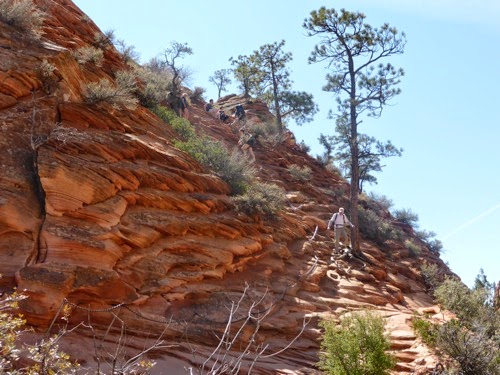
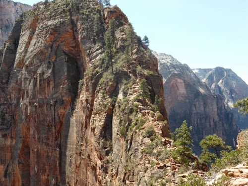
This is the trail we started on the other day and had to turn around as we were on the wrong one.  It starts out flat with a gradual incline and then we were on the side of one canyon wall with switchbacks taking us upward.  The next thing we knew we were climbing up a very narrow slot canyon on a steep paved trail to reach the backside of Angels Landing.  Then we  walked up 21 flights of switchbacks called the Wiggles to the top of the mesa.  We thought we had arrived but the signs said differently.  We still had another half mile to the end of the trail.  This is where it really gets scary!  The last part rises 500 foot traversing slick rock, narrow rock bridges and climbs one cannot make without holding on to the chains implanted in the rock. Sand made some places slick and deep steps cut into the side of the rock were taller than my stride.  We got about 1/2 way out and turned around to come back.  The trail was just too narrow for us (4-5 feet) on a rock bridge to Angels Landing with sheer drop offs on both sides of almost 1,500 feet!  This is one of the scariest things we have ever attempted.  I have to put it right up there with scuba diving and John compares it to flying aerobatics!

P1000811

The wiggles.

P1000809

The slick rock to get to the rock bridge. There is no way this could be climbed without the chains to hold onto! What you don’t see off to the right is the sheer cliff. Lose your footing here & you are toast. People get killed on this trail on a somewhat regular basis.

P1000806

The rock bridge up to Angels Landing. You can’t see the really narrow section.

P1000808

Angels Landing.

Monday, April 7, 2014

It's An Off Day

Our bodies needed rest!  We slept late, lounged around the campsite then cruised the campgrounds and main park area while riding our bikes.  After a late lunch we took in the Park History Museum and then rode the bikes into town and “shopped”.

Its hard to imagine how these towering canyon walls were formed as it has takes over 400 million years of wind and rain and a few earth moving events to create what we see today.  This all started with monster sand dunes in an area that covers Utah, Colorado, Arizona and New Mexico from the Zion and Bryce Canyons north and east to Grand Canyon, Canyonlands and Arches national parks, Colorado National Monuments and down to Mesa Verde and the Canyons of the Ancients.  The sand piled higher and higher and the pressure pushed down and compressed.  Then the whole area was pushed up into mesas.  Then 148 million years ago rain, rivers and streams started carving out the softer sandstone and depositing other minerals to cement the sands together.  But the raging rivers like the Virgin and the Colorado are what did most of the shaping during the past 50 million years into what we see today.

This area was first populated by the Ancestral Puebloans about 1500 years ago and later by the Southern Paiute peoples. Westward expansion brought the early Mormons until President Taft declared this a national monument. 

P1000805

View to the east from our campsite at dusk.

The evenings here are beautiful!

Sunday, April 6, 2014

Grotto or Groan-o?

We may have overdone the hiking today!  This morning, since it was pretty chilly, we drove the Jeep up about 2000 feet on the Zion-Mount Carmel Highway through the 1.1 mile tunnel.  This tunnel is a marvel of engineering since it was built from 1927-1930 by the CCC through sold rock, blasting and digging without todays modern machines.  We really wanted to see if we would be able to drive the RV through this tunnel since it is only 13’1” tall and we would have to buy a special permit so that we can drive down the middle of the road.  The RV is about 12’6” tall which does not give us a whole lot of wiggle room.  John was reassured that we would be able to do this after following a tour bus through the passage way.

P1000784

P1000787

P1000790

At the east end of the tunnel is a 1 mile round trip hike to the Canyon Overlook where we could see the road we just traveled up the Zion Canyon and also the fresh air windows into the tunnel.  We also had a great view of the Pine Creek Canyon.

P1000792

P1000794

Then this afternoon we decided to hike to the Emerald Pools and along the Kayenta Trail from the Grotto to the Zion Lodge.  Unfortunately we missed the turn off for the Kayenta Trail and walked an estimated 1.5 miles up the trail to Angels Landing so had to turn around and go back and start over.  So a 2.6 mile hike turned into a 5.6 mile hike with lots of ups and downs. And our legs were complaining and our feet were groaning.

The Emerald Pools (there are three of them) are created by water falling from the tops of the canyon walls and collecting in shallow indentations in the sandstone. There were so many people enjoying this area that it made it really hard to appreciate the beauty and quiet of the area and to get a good picture.

P1000798

By the time we got back to the RV it was too late to cook so we had dinner in Springdale, bought some wood and groceries before enjoying a nice fire and an early evening.

Saturday, April 5, 2014

The Narrows, Weeping Rock, Hidden Canyon

We were at the Southern Campground at 8 AM as advised, found a really nice site and were ready to explore Zion National Park by 9:30 am.  About 14 years ago this park began using buses to move people through the park instead of letting them drive their own cars. Not only does this cut down on crowded road ways and no parking spots but it is good for the environment and makes for hassle free exploring.  

P1000767

We took the bus all the way to the end of the road at Temple of Sinawava and walked along the Virgin River up into the canyon.  At the end of the walk we found people putting on dry suits and wadding boots preparing to walk in the river up the canyon into The Narrows. If we were to do this (which John is considering) we would have to rent the gear.  It could be a 10 mile hike round trip with 60% of the hike in water.  

P1000771

P1000772

We then rode the bus to Weeping Rock where water has worked its way through the sandstone and falls down the sides of the canyon wall.  Many variety of flowers and ferns grow on the rock walls forming hanging gardens.  It was very pretty.  

P1000774

P1000776

Near this walk is the hike to Hidden Canyon.  The sign says it is only 1 mile with 870 feet of elevation but our legs beg to differ!  Like many national parks, the CCC was used to construct many trails and buildings in the park.  This steep trail was mostly paved until we got to the upper reaches.  Then it was rock and sand and slick rock and sandstone.  

P1000781There’s Pam in the upper right on one of the ledges with the chains to grab on to.

In places the ledge was so narrow that grab-chains were attached to the wall so we could hold on to them and not fall!  When we reached the top I was breathing pretty hard and not sure if it was from the hike or from fear of falling!  We could have gone further up the Hidden Canyon but I’d had enough climbing and was worried about getting down so we turned around.  It was actually not as bad going down as I imagined.


Friday, April 4, 2014

Zion National Park

We left Lake Havasu early on Friday morning and got to Zion around 4 PM. We drove through the Virgin River Gorge on I-15 before entering Utah from Arizona.  What a fabulous drive for me, the passenger.  John got glimpses of the canyon walls and river as he navigated the RV down one lane on the highway with construction barriers on one side and a bridge rails on the other. Then it was a beautiful drive up to the park with towering canyon walls on both sides of the highway leading up to the entrance. 

Thinking it would be off-season until Easter,  we didn’t think we would have any problems finding a place to camp.  Boy were we wrong! According to the park ranger the park season starts the first of March and the campgrounds are filled to capacity every night.  We were fortunate that they were able to put us in a handicapped, electric site for one night and advised us to be at the other non-reservable campground between 8 and 9 the next morning.

Thursday, April 3, 2014

Lake Havasu

After a three hour drive across the desert and into Arizona on Monday, we settled into a site at Lake Havasu State Park with the provision that after two nights we had to change sites.  Luckily it is only seven sites down and we won’t have to do much to move.  Our GPS had us going almost 60 miles out of our way to get here so we ignored it.  Sometimes we wonder about this thing’s programming! 

The area hasn’t changed much since we were here two years ago.  The only thing different is that spring break is mostly over so there are fewer people here than before. We had lunch at our favorite burger joint on the London Bridge Canal.  Last time they had a goober burger but we had to settle for burgers with pineapple or blue cheese this year.  They are still really good though.

John got the kayak out and has fished some each day.  Yesterday was cloudy and threatened rain so he didn’t do much fishing.  So far he hasn’t had much luck.  We have ridden our bikes around town and I have gone on two run/jog jaunts trying to get back into some kind of shape. The park has a 1.5 mile nature trail along the shoreline so that has kept the walks interesting.  

Sunday, March 30, 2014

Aerial Tramway

After RJ, our son, attended some morning meetings on Saturday, we joined him, Lisa and granddaughter Ella for a ride up the Palm Spring Aerial Tramway. We drove up 2000 feet to the parking lot then the tram took us up to 8500 feet near the top of the mountain.  It was an interesting ride as the floor of the tram rotates as the tram rises so everyone has an opportunity to see all parts of the canyon we are soaring above. It was about 30° cooler on top but the views were great of the city and the mountain top forest made for a nice short hike.  If we were up to some strenuous hiking, there are over 50 miles of trails on the mountain.

P1000760

P1000764

P1000766

A trip to Pete Carlson’s Golf and Tennis store filled the rest of the afternoon.  Ella was one very tired baby so she went home with mommy and daddy while John and I attended a dinner for board members and past presidents of the ABMA.  We so enjoyed catching up with our friends at this function.

Today we played golf at the Indian Canyons Golf Course with our son.  This course has been around for many years, they used to host the Frank Sinatra Open.  Since it is tucked up against the mountain range, the high winds in the rest of the valley did not bother us on the course.  Actually, we were surprised at the high winds when we left there.

Last night we laid some plans for the rest of this trip.  We will head east to Lake Havasu then to Utah to visit Bryce Canyon and Zion National Parks.  After Easter with our daughter in Oklahoma we will head home.  But there will be plenty of adventures before that time.

Saturday, March 29, 2014

Outdoor RV Resort and Earthquake!

Wednesday we moved from Cahuilla County park to an RV Resort.  This place is huge!  It has over 1200 RV sites, all of which are privately owned, but some are rented out if the owners are not staying here.  We got lucky.  The resort has an 18-hole, Par 3 Executive golf course and a 9-hole, Par 3 pitch and putt course.  There are two club houses, each has a pool, tennis courts, dining establishment, laundry facilities and spa.  Then there are six satellite buildings, each with a small pool, hot tub, showers, laundry, and a tennis court.  If you don’t own a bicycle or golf cart you might have a hard time getting around!  Most sites are big enough to hold a large BBQ grill, table and chairs, loungers and potted flowers.  Hedges separate the sites so you have some separation from your neighbor.

RJ and Lisa and Ella are attending a convention at the Westin which is only about 3 miles from us.  We are babysitting Ella while they attend cocktail parties each evening.  But we are also playing with her during the day.  Okay, and hanging out with her parents! HA!

Last night, while babysitting, we experienced our first earthquake!  Since the room was on the second floor, I’m sure we felt it more than people on the ground.  But the room shook pretty hard and then wiggled for several seconds after that.  It was enough to wake up the baby!  Kind of weird and exciting at the same time.  It was 5.1 with the epicenter in LA, about 2 hours drive from here.

Wednesday, March 26, 2014

Golf, Shopping, and Bike Rides

Sunday we played golf at The Golf Club at La Quinta with our friend Mike and his friend Ray. It was a beautiful day and a beautiful course.  John played pretty well and I had a great front nine and a bad back nine. We met the other wives for a late lunch.  


Monday Diane and I went shopping!  Oh, it was wonderful!  We then met the guys for a mid-afternoon pizza and had a great visit afterwards. 
 
Today we got the bikes out and rode the flat roads for 15 miles while exploring some of the side streets.  We would have liked to ride in one of the subdivisions but they are all gated and locked tight so we couldn't get in.
 
The wind kicked up about supper time and is expected to continue through tomorrow. Around here that is bad news as the dust is horrible. At one point we couldn't even see the mountain that's only 3-4 miles away because of the "particulates" in the air.  Thank goodness for A/C.

Sunday, March 23, 2014

Back to Civization

Wednesday we departed the wild, untamed (ha) desert and drove to Palm Springs where we stayed two nights in Desert Hot Springs at Sam's RV Spa Resort. We took advantage of their mineral hot springs to cleanse the sand out of our pores. 

Friday we moved to Cahuilla Lake County Park near La Quinta.  We have stayed here in the past and found some good hikes in the mountains and we love riding our bikes on the flat roads which are very biker friendly. Our friends, Mike and Diane, recently moved to La Quinta so we wanted to meet up and hang out with them for a few days. Besides they have lived here long enough to find the really good restaurants and golf courses!

Last night we celebrated Mike's birthday. Today, we are golfing!  We'll see how that goes. 

Tuesday, March 18, 2014

Devil's Wind and Diablo Drop

Yesterday was a mixed bag of activity.  We had made a 10:30 am tee time at the only 18 hole golf course in the valley and since we had not really played that much, we showed up an hour early to practice.  We could have gone on and played early and probably should have done so.  The weather forecast indicated that high winds would enter the valley around 2 pm and we figured we would be off the course by then.  Well, the winds hit the course about 12:30 just as we were making the turn and it made for a really bad back nine. We hurried back to the RV, pulled in both slides and hunkered down to wait out the 45 mph wind storm.  By bed time the Devil’s wind had died down to a small roar.

P1000745

This morning was a very lazy one for us as we just couldn’t muster up any energy to do much of anything.  But we finally fixed a lunch and took off for an afternoon of off-roading in Diablo Canyon.  And I’m so glad we did.

The first half of our drive was down the Arroyo Tapiado, a gentle, sandy run until we entered the Mud Caves or Mud Palisades.  We drove along side of tall walls of dried sand and mud created millions of years ago by the ocean that covered this whole southern part of California.  The mud walls have since been recreated by wind and rain to look like caverns and slot canyons.  At times we drove in narrow washes towered over by leaning walls of ‘mud’.  

P1000746

As we drove along Arroyo Seco Del Diablo we neared  the drop off to the next wash.  The Diablo Drop was supposed to be a heart stopping drop down a steep and very soft sand road. It was steep and it was soft sand but it was not heart stopping, not compared to some runs we have done in Colorado!  Still it was fun.

P1000747

P1000750

P1000751

We then cruised Fish Creek towards Elephant’s Knees along the East Mesa and Mud Hills.  The best views of the Knees was from the Wind Caves.  These are soft boulders where the wind and rain have carved out many holes in the stone, some forming caves, others tunnels and arches.  It was a neat area to explore but the view of this badlands area was spectacular as viewed from the top of the boulders.  We drove though more slot canyons and sandy washes before hitting the paved roads home.

P1000749

Sunday, March 16, 2014

Blair Valley and Oriflamme Canyon

One of the reasons we wanted to come back to this area was so we could do some off-road Jeeping.  We packed a lunch and headed to Blair Valley which was a very easy drive on sand and between mountains.  One stop on our route allowed us to hike two miles to see some Indian petroglyphs.  It was fun walking among boulders and around cacti!

P1000742

Once we exited Blair Valley we drove to Oriflamme Canyon.  It is purported to be a moderately difficult drive and we found that to be the case.  Mostly it was very bumpy but there were a couple of areas where boulders had fallen on the road and John had a very tight squeeze between them and the edge of the cliff!  We thought John was going to play the Good Samaritan again today.  The SUV in front of us had pulled off the trail and the driver thought he was having engine trouble or transmission problems.  So we pulled up and as John was getting out of the Jeep, the other guy tried starting his car and it started and he got it into gear with no problems.  It had us scratching our heads!

P1000743

This road had us traversing the side of the mountain with lots of switchbacks and very narrow ledges on which to drive but it was a ruggedly handsome region with steep sided mountains, rocks, boulders, cacti, ocotillo, and creosote bushes until we would drop down into the valley and find green trees and brush along a reed enmeshed creek.

Hot, bright sun with little wind during the day but the full moon and clear skies have cooled us off for the night.