Friday, September 23, 2016

It Must Be Fall

The weather has turned on us! For the first time since mid-July it is raining. The rain started as we drove to Durango, quit before we got to Wolf Creek Pass and then started again Wednesday night.

John was able to do some fishing on Thursday morning but then the clouds moved in after lunch so we drove up to Creede to use the internet at the Visitor Center and then to do some shopping. We had a couple of drinks at Tommyknockers Bar and enjoyed visiting with a couple who had been in the Baja last February at a place we had been the year before.

We tried to build a fire last night but the wood wouldn’t catch and then it started raining again. This morning was nice with sun and clouds and got up to the low 60’s for a short time. John fished (he had a little bit of luck) and I walked along the Denver & Rio Grande Railroad track. There is a small diesel car that runs from South Fork to near Creede once a day. They stopped at the campground to use the toilet so I got to visit with a couple of the passengers.

Right after lunch more clouds rolled in and it started to rain and spit a little snow all afternoon as the temperatures started dropping down to 40! It is supposed to get below freezing tonight! I think John may appreciate a dinner at a restaurant so he doesn’t have to freeze while cooking on the grill. And we will move on to a warmer climate in Pueblo tomorrow. It’s too early for snow!! Brrrrr!
Wednesday, September 21, 2016

Jahraus Crossings

We left Capitol Reef Monday morning and enjoyed a scenic drive across Utah towards Colorado. The Colorado River has cut through the land to create Glen Canyon but the headwaters of Powell Lake were not visible where we crossed due to low water levels.

P1000891
P1000892

Our friends Jeff and Linda invited us to park in the driveway of their mountain cabin on the Dolores River just north of Dolores, CO. We had a delightful two days with them with a lot of talking, wine drinking and eating. Tuesday morning we drove into the San Juan mountains to take in the fall colors and to look for the local moose. To offset the food and wine we hiked up to Geyser Spring which is not too far from the Dunton Resort. It is not a hot geyser but as we were looking at it the bubbles increased as if it were going to spew water into the air. The rotten egg smell also increased with the bubbling.

P1000893
P1000894

We reluctantly left Jeff and Linda’s on Wednesday morning and drove to Durango where we had lunch with our friend Dave. After a quick grocery stop we drove across the southern’s part of Colorado and up Wolf Creek Pass. John doesn’t know if there is a problem with the RV but we could only go 15-25 mph over the eight miles it took to get to the top of the 10,550 foot pass. This has never happened before!

Our destination is Palisades Campground in the San Juan National Forest between Creede and South Fork right on the Rio Grande River. We have stayed here before so are looking forward to some fishing and quiet river sounds.

Sunday, September 18, 2016

Cassidy Arch Trail

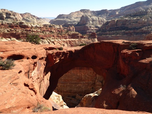
There are rumors that Butch Cassidy and the Sundance Kid hid out in the canyons of this park. We did not find their hideout but we did see the Arch that was named after Butch.

P1000885

P1000886

Since the hike involved a 670 foot of elevation climb we chose to only hike this trail (3.4 miles) and not the one connected to it that would have taken us back to the campground. It started off steep with lots of switchbacks but once we reached the top it leveled out some, then we were walking across slick rock. We got our first view of the Arch about half way up but at the top we could look down and through the Arch from the top and even walk out on top of it. The views from the top are awesome! I think this has become one of our all time favorite National Parks.

P1000888

P1000889

Having stayed in this campground for over 6 days, it was inevitable that we would meet some people. It turns out that one of the Campground Hosts has similar interests to ours. We ran into them while driving near Fishlake on Friday, then again on Saturday at the Harvest party, again at the Jazz concert and today they were on the Cassidy Arch Trail! We will need to exchange addresses with Ron and Mary because I bet we travel in similar circles too.

Saturday, September 17, 2016

Harvest Celebration

Since this is the 100th Anniversary of the National Park Service, Capitol Reef hosted a Harvest Celebration at the Gifford House and barn. Starting about noon they had food booths, lemonade and fresh pressed apple juice. A collection of booths showed how some things were done in the early 1900’s such as cattle branding, turning wool into clothing, crocheting, quilting and broom making. Two authors were signing books and several musicians kept us all entertained. Late afternoon the park employees put on a Jazz concert. Most of the musicians had their Ranger uniforms on. Then there was a Barn Dance but we elected to enjoy a campfire instead of dancing.

Earlier today John and I took a hike back up Fremont River. This is the same one I hiked earlier this week. It’s still a good hike.

Friday, September 16, 2016

Cathedral Valley

There are so many places to view the magnificent rock formations in Capitol Reef National Park. We have hiked several trails and driven along the Scenic Road and Hwy 24 so today we went off the main roads and traveled a gravel road recommended for high-clearance vehicles. 

The Cathedral Road started about 16 miles outside of the park in Caineville on Hwy 24 except that Caineville is not any more than a hole in the road, and there was no sign! So we drove past the turn off to Cathedral Road by about 8 miles, turned around and almost drove past it again! Then John let me drive so he could be the sightseer for a change. I don’t think I scared him to badly!

P1000869

P1000870

We had only made it about 5 miles when we stopped and aired down the tires due to extreme washboarding on the gravel road. That helped some but it was still really bumpy. In fact, it was so bumpy that my FitBit recorded each bump as a step and I logged 18,000 steps in the Jeep!

P1000874

P1000875

We drove past more fabulous rock formations, canyon walls, and desert landscapes. According to the map we passed the North Caineville Reef, Red Desert, Wood Bench slopes, the Middle Desert, the Monoliths and, of course, Cathedral Valley.

P1000876

P1000880

One set of rocks were called the Temple of the Sun and the Temple of the Moon. The Canyon walls all along the Valley reminded me of Notre Dame Cathedral in Paris, another setting felt like the Throne of Zeus or temples for the Greek Gods.

P1000882

At the end of the road we headed up into the Fishlake National Forest where the topography changed to mountain forests with golden and fiery Aspens among the cedar and pine trees. Fishlike was invitingly blue and John wished we had more time here so he could try his hand at fishing on it.

It was a long drive back to the RV park.

Thursday, September 15, 2016

Going Our Separate Ways

John arranged for a guided fishing trip today so I made plans to hike and explore the valley. John left at 7:30 and just as I was about to leave the RV he came back. The fishing guide service forgot to log him in for a fishing trip this morning. The gave him a free cup of coffee and arranged for an afternoon fishing trip. They said it would be better fishing then anyway.

P1000867

P1000868

I walked around the valley then took the Fremont River trail for a 2.6 mile hike along the river and then a 480 foot climb to the top of a canyon with a fabulous view of the Fremont Gorge on one side and the Fruita Historic Valley on the other side. Very enjoyable. John probably will regret letting me have the camera today as I took a lot of photos that we threw out because I kept taking pictures of the same thing, just at different angles.

John had a nice afternoon but unfortunately no fish were caught although he did lose two.

Wednesday, September 14, 2016

Pleasant Creek Trail

We are so enjoying Capitol Reef National Park! Everywhere one walks or drives there is beautiful scenery. Today we drove to the end of the Scenic Drive then continued on the South Draw gravel road to the Pleasant Creek Trailhead.

P1000854

P1000855

This hike was much different than most hikes we take as there was no established or maintained trail. We followed the footpaths left by other hikers, game trails left by deer and created our own path the rest of the time. We stayed close to the creek going out but took a lot of shortcuts across open ground and over hills on the way back. As the fast moving water cut into the sides of the canyon, we would have to cross over to the other side and we did this quite often. Most of the time we found rocks to hop across on as in most places the creek was too wide to just jump across, other times we walked down a sand bar in the middle and on the way back, when I’m tired of all the searching for a good crossing, I just walked in the water!

P1000858

P1000859

The hike was about 6.5 miles round trip (18,000 steps on our pedometers) and took about 5 1/2 hours including a stop for lunch. The canyon was wide at the beginning and got narrower the further we walked then it opened up again near where we turned around to come back. Because of the wind, it was a good day for a hot hike.

P1000860

Instead of returning to camp the way we came, we took the unmaintained Jeep trail. It followed a wash along the canyon bottom then started to climb. We had to use 4-wheel drive and shifted into low to get up the hill sides. It was fairly technical in places but once we reached to top of the canyon, it was just rocky. We saw more of the ‘Reef’, deep canyons, open fields and dense forests. It was a pretty drive. When we hit the maintained gravel road we thought we should be done but the road just went on and on, and there were no signs indicating we were going in the right direction, and we had no idea if we had missed a turn, and there was zero cell service so we couldn’t locate ourselves on our phones! In another mile we would have gone into full panic mode but just then we hit the highway! Whew! Close call! We drove over 30 miles to get back to the RV over a 9,000+ foot pass where the temperature was already in the 40s. Since it was so late in the day we “had” to stop in Torrey for dinner.

P1000862

It was a very long day but one we enjoyed immensely!

Tuesday, September 13, 2016

Cohab Canyon

We spent the morning moving into the campground and getting the RV set up. Good thing we got here a little after 9 as there were only 3 spots available. Since the park is in a hole, so to speak, there is no cell signal. John tried our booster but there was nothing to boost. We will have to drive into town periodically to post this blog and to retrieve email & phone messages.

We met a van load of senior women parked next to us. John was their hero as they had a flat tire and he was able to air it up for them. These 5 women with an average age of 72 (the oldest is 87) go hiking together in Boston and decided to take this trip to Utah. They flew into Salt Lake City, rented a mini van with a roof tent on top. 2 slept in the van, 2 slept on the roof and one slept in a tent on the ground. They’ve been doing this for almost a week and this was their last stop. Such a fun group - I envy them for having this time together.

P1000838

P1000842

The Fruita Historic District in the valley was settled by Mormons in the 1880’s along the Fremont River. They planted orchards and pastures and lived an agrarian life for decades. Today the National Park Service maintains all those orchards and opens them up for the visitors to pick some for personal use. They have not only apple and pear but cherry, apricot, peach, plum & quince along with almond, walnut & pecan trees. I got some pears and apples which is all that is ripe this time of year. We also bought an apple pie home made right here in the valley.

P1000846

P1000849

P1000847

John and I delayed hiking this afternoon because the weather acted like it was going to storm but as each black cloud scudded past it only sprinkled rain. We finally headed across the street and up into Cohab Canyon. It was a 440 foot hike up then about 1.5 miles into the canyon. It is a narrow slot canyon with hidden canyons along each side. Near the end we climbed out up onto a mesa where we had striking views of the Fruita Valley below us and higher canyon walls on either side. We walked about 3.8 miles total.

Monday, September 12, 2016

Another Pile of Rocks aka Capitol Reef

Rocks, rocks and more rocks is what John keeps saying as we drive along the cliffs and canyons of Capitol Reef National Park. But don’t let his trivial description fool you. The views are magnificent!

We left Deer Creek Sunday morning and drove south to Richfield, UT about 70 miles from the park so that I could do laundry and stock up on groceries. Monday morning we left rather late and took our time driving to the Capitol Reef, even stopping to visit with a National Forest ranger about fishing and off-highway drives then stopping for lunch. Next to the hamburger joint was a store & guide service. John got to visiting with them and ended up booking a half day guided fishing trip for Thursday. We arrived at the park about 2 pm on a Monday afternoon and the campground was full! Usually this plan of arriving on a Monday or Tuesday works well. We heard at the visitor’s center that the campground surprisingly filled up before noon.

P1000831

P1000832

P1000833

We were directed to a BLM camping area about 6 miles west of the park entrance. There were already 4 others camping there and when we came back that evening, it was almost full also. We drove back to the park visitor center after parking the RV to talk with the rangers about some hikes and then drove down the Scenic Road to the Capitol Gorge trailhead. We were just in awe of the massive cliffs and towering walls of red rock all along the roadway. Our hike was just short of two miles out and back in the canyon of Capitol Gorge. We saw Native American petroglyphs and late 1800’s graffiti on the smooth walls of the canyon.

P1000834

P1000837

According to the literature we got, this area was created by an environment that was once an ocean; it was then heaved upward and folded over instead of cracking; and then erosion did its thing to create canyons, cliffs, domes and bridges. The area got its name ‘Reef’ because it looks like an ocean reef and divides the land like a reef would.

Saturday, September 10, 2016

Deer Creek State Park

We left Antelope Island Friday morning and drove a whole 95 miles through Ogden, Salt Lake City and Provo to this state park in the mountains along the Deer Creek Reservoir. Its not the best campground but its location is good.

P1000824

We are just a few miles from Robert Redford’s Sundance Ski Resort so yesterday afternoon we drove over there to explore it and have a cocktail before dinner back at the RV. While enjoying the mountain view and a warm fire in the fire pit, we overheard the couple next to us mention they were in an RV and headed toward the Grand Tetons and Yellowstone. I opened the conversation by mentioning that we also were in an RV and loved the Tetons. Things progressed from there. We had more cocktails, joined them at their table and exchanged stories of our RV travels and our world travels. Tim and Kristi were delightful people and we enjoyed our time with them immensely. They will eventually end up in St. Pete Beach where they have a cottage not too far from my brother. Maybe we’ll meet them again!

P1000826

P1000828

Today, after a very lazy morning, John planned a driving tour for us. We drove up to Deer Valley and Park City Ski areas where we shopped and lunched. We then took the Big Cottonwood Canyon Road up over Guardsman Pass stopping to take pictures and a short hike. Driving down Big Cottonwood Canyon we passed the Brighton & Solitude ski areas and admired Storm Mountain. Then we went around the end of the mountain and back up the other side to Alta and Snowbird Ski Area’s which are in Little Cottonwood Canyon. We would have stopped but all the parking areas were totally full of people attending the October Fest at Snowbird. Back down and a bit further south we drove back up the Alpine Loop through canyons and mountains, over winding switchbacks and steep grades on a very narrow road and back to Sundance. This time we didn’t stop as it was after 7 pm and we were hungry!

Thursday, September 8, 2016

Bison, Antelope and a Ranch

P1000815

P1000814

The weather has been so nice, sunny and warm. This morning we took a 5 mile hike along the Great Salt Lake shoreline. The lake was filled with birds as far as the eye could see, just floating around and they were too far out for us to determine what kind of bird. Since it was an out-and-back hike we watched for the birds and they were all gone on the return leg! No sign of them anywhere! Very strange. During a rest stop along the trail, John was almost run over by a very long snake! No idea what kind, but once John moved his foot, the snake changed directions.

P1000821

P1000823

This afternoon we drove down the east coast of the island. This side has been reserved for the animals - bison, antelope, deer, etc. Very few trails into the mountains so that the bison are not disturbed by humans. We saw several large herds of bison and several prong horn antelope grazing along the shore where several of the 40 freshwater springs line the salt flats.

P1000817

P1000819

In 1848 the Mormon Church assigned Fielding Garr to establish a ranch on the island as a stronghold for the church’s tithing herds. The ranch has been owned by many others through its 150 year history. They’ve raised cattle and sheep on the ranch and added the bison for hunting opportunities but in the process saved them from extinction. In 1981 the ranch and island became a state park and the cattle operation was ended. Today, the ranch house is the oldest adobe structure still standing on its original foundation. Visitors are encouraged to explore the barns, spring houses, bunk house and corals to learn about ranching over the past 150 years.

Wednesday, September 7, 2016

Golden Spike

On our way to Antelope Island north of Salt Lake City, we detoured to visit Promontory Summit where the railroads from the east and west met to join all of our country together.

Central Pacific left Sacramento, CA in January 1863 and started building their line westward through the Sierra Nevada Mountains and across the Great Basin of Nevada while Union Pacific started that December from Omaha in the Nebraska Territory, across the plains and the Rocky Mountains. Central Pacific had to use Chinese immigrants to build their line as most of the able men were mining for gold but the Union Pacific was able to hire former soldiers from the Civil War. Central Pacific battled the mountains while Union Pacific battled the Plains Indians. It wasn’t until mid- 1868 that the track laying built into a race to grab the most land. On May 10, 1869 the two locomotives - Central Pacific’s Jupiter and Union Pacific’s No. 119 - met head to head at Promontory Summit where a golden spike was symbolically driven to connect the railroads and the country.

P1000801

P1000811

The two steam engines we saw today are exact replicas of the two from 1869. They were built by a Walt Disney engineer in 1970’s and refurbished again in the 1990’s.

We continued on to Antelope Island in the midst of The Great Salt Lake. It is connected to the mainland by a 7-mile long causeway. The Island contains a herd of over 700 bison, as well as mule deer, pronghorn antelope, California bighorn sheep, Jack rabbits, coyotes, bobcats, badgers, porcupines and lots of birds like quail, magpies, eagles, and owls. A big bull bison grazed his way past our campsite late this evening!

IMG 3315

We also met a delightful family from France and New Zealand this evening. Their 7-year old daughter captivated us with her observations of the bison, jackrabbits and quail. This led to us visiting with her parents and her brother and sister. They freighted their motorhome from France to Canada so they can travel through the US all the way to Argentina! Brave and exciting people!

Tuesday, September 6, 2016

Is That One, Two or Twin Falls?

We packed up Monday morning and headed off to Twin Falls before we drop down into Utah. As we pulled into the county park campgrounds, we thought we had the wrong spot at there was a huge party being held by Indians (folks from India), but at the far end of the park were some empty campsites. We quickly set up camp then took off to find all the falls along the Snake River. 

P1000792

P1000794

P1000796

Shoshone Falls gathered the most tourists, but at this time of year there was not enough water going over the drop to call it the Niagara of the West. Still it was impressive. Most of the water in the Snake River is diverted to irrigation canals for potatoes, wheat and other crops. We drove over to the Twin Falls and again we were disappointed because half of the falls has been damned up to be used for electrical generation. 

P1000799

But we were not disappointed in the scenery as we dined at Elevation because they overlooked the two golf courses in the bottom of the canyon and had a great view of the bridge spanning the canyon. 


IMG 3311

The view of the golf courses convinced John that we should play a round on one of the courses, so on Tuesday morning I made tee times for us on the Canyon Spring Golf Course. It was so nice and very pretty. From the bottom of the canyon we could see several waterfalls spilling over the canyon walls. I played a pretty good game and John did okay.