Grandparents camp continued.
Traveling in our 35 foot Newmar Ventana RV plus a few planes ships & trains!
Tuesday, July 12, 2016
Days 2, 3, & 4
Saturday, July 9, 2016
Grandparent Camp
Luca and Vincent arrived on Friday. Their mom and dad stayed for supper and then took off to KC to stay at the airport motel as they had a 6 AM flight to Portland, OR. The boys were up at 6:30 and it has been non stop all day. While I was at the beauty salon getting my hair done, John played ball with the boys and then took them on a hike thru the woods behind our house. They watched TV while they ate lunch and John and I tried to rest up for the afternoon fun.
I got out my ‘Experiment Kit’ and we played mad scientist by exploding the lid off of film canisters and recording the results. We timed how long it took to blow the top off and then how far the canister would shoot out of a tube and then we tried to shove a toy car down the driveway with an exploding canister. About that time the heat was just too much so we met the RJ Lindstrom family at the country club pool and cooled off in the water for a couple of hours.
Pizza for supper with Liam and Ella at their house and RJ shooting off leftover fireworks at dusk rounded out our day. We are pooped and its only been one day!! 7 more to go!
Tuesday, July 5, 2016
Back to Missouri
We left on Saturday for the drive back to Missouri. We are still fighting the GPS and having to use the AAA map to guide us along the back roads and through the towns. That and some rain slowed us down until we got on the interstate. We stayed in St. Charles Sunday and Monday (the 4th of July) and had a lovely visit with my Mom and Bernie. It rained off and on all weekend and we totally missed all the fireworks while we played an exciting card game of 3/13.
We arrived home just in time to endure the summer heat wave - 96°+ with a heat index of 102° in which to unload the RV and get the house ready for company. We will be keeping our two Oklahoma grandsons for a whole week while their parents enjoy a Columbia River Cruise in Oregon.
Friday, July 1, 2016
Pig, Cub Run, Sweeden
Having exhausted ourselves with hiking and biking over the last few days, we decided to take a car ride around the perimeter of the park to explore the small towns and to take a short hike.
I was fascinated by the names of the towns we went through like Pig, Cub Run, Sweeden, Scotland, Munfordville, Cave City, Park City, and Horse Cave. We got off the beaten path and traveled down a one-lane gravel road, past an old cemetery and across a dry creek bed at the bottom of a steep ravine. Shortly past the creek we were stopped by about 6 National Park Service vehicles parked in the middle of the road. As we approached a ranger got out of his truck and stopped us. He said, “There’s a personal safety concern ahead and we have to ask you to turn around and go back. Try the road again this afternoon, it’s a beautiful drive.” What in the heck is a “personal safety concern”? We don’t know, use your imagination!
We then found a 2.6 mile trail that led to the river so we started down it, went about 1.5 miles, stopped for lunch and then came back. It was just too hot to continue to the river. One small town advertised a Farmer’s Market but when we found it there was only one lady selling her produce. Most of the small villages had many empty buildings, some historic ones and then you were out of the city limits. We also crossed the Nolin Lake Damn and, too late, discovered that John could have trout fished below the dam.
By the time we got back to the RV it was time for a cocktail and dinner preparations.
Thursday, June 30, 2016
Mammoth Cave Railroad Hike & Bike
Following the Civil War, tourism at Mammoth Cave started to grow and the railroads wanted to be a part of that. A spur line was built from Park City, KY up to Mammoth Cave and ran for about 10 years. Today the old rail bed has been converted to a 9-mile hiking and biking trail starting at the Visitor Center and running to Park City (18 miles round trip).
We got a late start on the bikes but were able to get to Park City by lunchtime. It is not your typical rails-to-trails path as they had to work around existing roads and attractions so there were several very steep climbs along the way, especially coming back. We had lunch at The Grand Victorian Inn Bed & Breakfast. What a delightful place. It was built as a hotel in 1885 and was used as a boys home, a nursing home and as a private home through the years. About 14 years ago it was bought by the current owners and made into the Bed & Breakfast. It is beautiful.
I know you have heard this before, but I really struggle going up hill! Today it seemed worse but we made it back and had a nice dinner and a campfire.
Wednesday, June 29, 2016
Springs, Drips and Domes
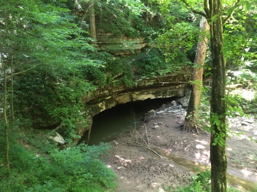
We had a very busy day today. I convinced John that we should do a ‘short’ hike this morning around the visitor’s center. It ended up being a little over 4 miles but we got to see the Echo River Spring and the River Styx Spring. Even though the River Styx is a river in Hades it is a pretty spring that also comes out of the bottom of Mammoth Cave. We viewed the forests for miles around from the Sunset Point, climbed hills, spotted an old stone cabin and enjoyed the cooler weather.
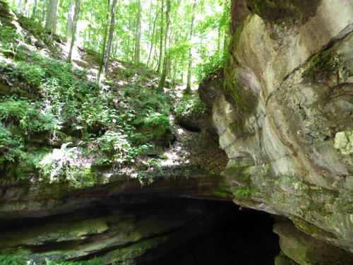
Our second tour into Mammoth Cave began at a different entrance than yesterday. We learned that there are 23 possible ways to enter the cave but only 5 are used on a regular basis. The entrance yesterday was the Historic Entrance, today’s tour began at the New Entrance and we came out at the Frozen Niagara Entrance. The other two entrances are used mostly by spelunkers.
The New Entrance is manmade as an enterprising individual wanted to capitalize on the popularity of Mammoth Cave but have his own tour not connected to the main cave. He found a spot where cool air was coming out, blew it up with dynamite and found a 252 foot open column or Dome that dropped down to a floor that would eventually be found to connect to the Rotunda Room. The first tourists in this entrance descended by rope, then by wooden stairs. Between 1965 and 1985 no one went into this part of the cave until the National Park Service spent $1 million to build a 280-step steel staircase. In most places the steps were no wider that our shoulders with rocks jutting out over the stairs in many places and water dripping on our heads. But it was amazing to see and to experience.
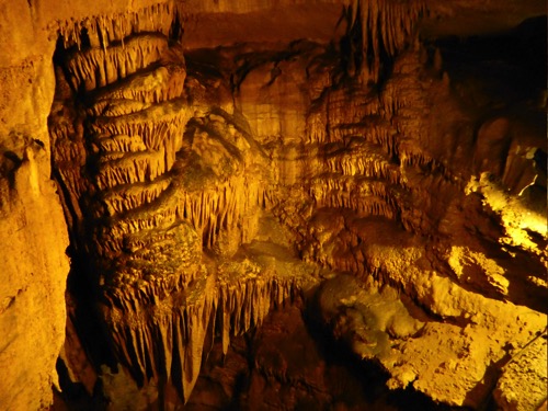
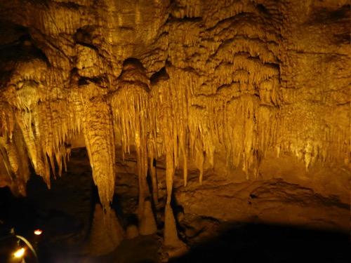
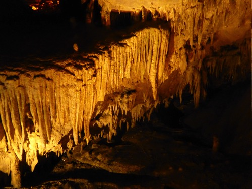
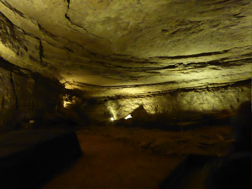
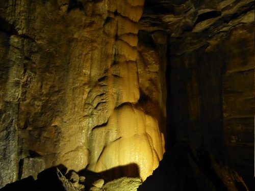
The Dome column is considered a living, vertical cave because the water is still carving out the rock. The next portion of the tour was in a room that was very dry and unchanged over thousands of years. It is considered a dormant cave. The last room we were in is considered a dying cave. It has lots of stalactites and stalagmites, dripstone formations and wondrous ceilings. It is called a dying cave because eventually it will fill back up with the limestone formations. But that won’t happen for millions of years.
In the meantime we certainly enjoyed the beauty of these formations. There was the Frozen Niagara Falls, Bacon formation and other interesting stalagmites that waved like curtains from the ceiling.
Tuesday, June 28, 2016
Mammoth Cave National Park
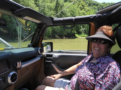
We chose to do a cave tour in the heat of the day so we got on our bikes to explore the area this morning. Our first trek led us down hill to the Green River Ferry Crossing. I did say DOWN hill, which means we have a long slog UP hill to get back to the park visitor center. We started down another road but realized it, too, was down hill so we turned around, quickly! A quick exploration of the remainder of the main area of the park and then back to the RV. I fixed a picnic lunch and then we got into the Jeep and drove to the ferry crossing. Its much easier to drive than to bike!
We crossed the rive and found a one lane gravel road that went into the forest. We stopped at an old cemetery where more recent burials have happened but there is evidence of graves from the late 1800’s.
After lunch we took our first cave tour. Mammoth Cave is the longest cave in the US with 405 miles of explored passages. It’s first inhabitants were the pre-historic native Americans. Then in the early 1800’s it was again discovered. During the War of 1812 it was mined for saltpeter and was used as a sanitarium for TB patients (didn’t work), and mined for gypsum but it’s importance is as a tourist attraction. Tours have been given for 200 years, it has been a part of the National Park System for 75 years and the National Park is celebrating its 100th anniversary this year! Its first tour guides were slaves enlisted for this service and one of its most prominent explorers was a black guide, Stephen Bishop.
We walked 2 miles with 120 of our new friends. We saw the rotunda, walked across the Bottomless Pit, squeezed through the Fat Man’s Misery and climbed 155 steps up the Mammoth Dome. It is a very dry cave but one spot where the water dripped through is called the Butterscotch Sundae. It’s dry because it has a sandstone cap covered with forest. The Dome was formed when that cap collapsed and caused a sink home. More tomorrow.
Monday, June 27, 2016
Lincoln's Childhood Home
We left Lexington using our alternate GPS because we are so unhappy with the other one. If you were wanting to turn onto KY 121 and the GPS told you to turn on Iron Ore Road, wouldn’t you be a bit confused? We were confused constantly! This GPS is on John’s iPad and at least it give highway numbers but, it too, seems to want to take us down some pretty narrow and winding roads just to save 1 mile! This has caused some confusion and consternation as John doesn’t believe I can read a map well. Anyway, we got to Mammoth Cave, eventually.
Along the way we stopped at the childhood home of Abraham Lincoln. Most of what he experienced as a child was speculation with a few quotes from old Abe. I guess he got into trouble a lot by trying to follow in the footsteps of friends, like falling into a flooded creek and having to be rescued by said friend. The spot where his family lived is marked by a small log cabin and a large building that at one time was a popular road house to drink and dance.
We were worried that we would not be able to find a campsite in the Mammoth Cave National Park, but since we arrived well before the 4th of July, we have a prime spot and nobody can take it from us since it’s a walk-in site you can’t reserve.
Sunday, June 26, 2016
Bourbon Trail
A couple of years ago we visited Bardstown, KY and took in three distilleries on the Bourbon Trail in that part of the state. Today we visited three distilleries on the Lexington end of the Bourbon Trail - Wild Turkey, Four Roses and Woodford Reserve.
But first I attended a Cowboy Church service held here in the campground. I was expecting maybe 10-20 people but as I walked up to the pavilion there were only two men and a van with the Cowboy Church logo on the back. One man was the ‘choir’ and the other man was the minister and there was me as the lone member of the ‘congregation’. An interesting 45 minutes.
Wild Turkey Distillery was our first stop. Located on the Kentucky River we crossed over it on an ’S’ curved bridge, one of only two in the US. Next to it was a neat looking, but rusted out, railroad bridge. We found out later that a private company purchased it so they could reinforce the bridge for the business of bungee jumping. So if you ever want to bungee jump a couple hundred feet over a river this is your place. We took the whole tour and then tasted four of their bourbons.
I’ll remind you that all bourbon is a whiskey but not all whiskey is a bourbon. Fifty one percent of bourbon must be made from corn and the rest is rye and barley grains. (Whiskey can have less than 51% corn). It must be cured in a new charred oak barrel and the barrel can only be used one time. You cannot call the spirit ‘bourbon’ until it has been in the barrel for a minimum of 4 years. One of our tastings was actually not a bourbon but a blend of bourbon and rye whiskey. Our other tastings were of small batch or single barrels. John liked one of the single barrel bourbons while I did not like any of them.
Our next stop was at Four Roses Distillery. We chose not to tour but just to do a tasting. They had only three styles of bourbon - their yellow label is a young spirit, then they had a small batch and a single barrel. John liked their single barrel. I did not like any of them.
After a picnic lunch under the Four Roses gazebo we traveled to Woodford Reserve. This is one of the oldest distilleries in the US. Again we chose to forgo the tour and just taste their bourbon. Their claim to fame is that they distill their alcohol three times in copper pot-style stills while the other distilleries only distill once and use a more modern stack-style still. They only make two bourbons - one is the regular bourbon aged 8-10 years and the other is called a double oaked bourbon because they take the bourbon from the original oak barrels and aged them for an addition 12-18 months in another oak barrel that has been toasted (baked) as apposed to charred or burned. John liked their regular bourbon and I did not like either one.
Did you see a pattern here? I really do NOT like bourbon. I’ll take an Irish whiskey any day!
All of these distilleries were located in the heart of Kentucky Bluegrass Country where rolling hills are lined with black or white fences and a number of Irish style rock walls and many horses. Some of the stables were architecturally nicer than many homes and the huge homes were beautiful southern mansions. It was a beautiful afternoon for a drive in the country.
We ate supper at the Red State BBQ restaurant. Some very, very good BBQ.
Saturday, June 25, 2016
Legacy Trail To Lexington
The Legacy Trail is a biking and walking trail that runs from the Horse Park to downtown Lexington, a distance of about 9 miles. We made it longer by taking a few missed turns but it was a nice trail by farms, stud farms, KU agricultural projects and then into the downtown area. We rode past Transylvania University, the oldest college west of the Allegheny Mountains, established in 1833. Gratz Park is a pleasant area of beautiful old homes, shaded lanes and parks with fountains. One of the home was the Hunt-Morgan House, home of the "Thunderbolt of the Confederacy” John Hunt Morgan and Thomas Hunt Morgan who is a Nobel Prize winner in genetics. I wanted to see the house but John didn’t and because they were not busy I got the $3.00, 10-minute tour.
We then headed to the center of town looking for the Farmer’s Market and found the Gay Pride Festival. I guess I should use the politically correct name - LBGT Festival. There are some really weird people in this world. A quick walk through and we headed to the Farmer’s Market, got some fresh fruit and then had lunch at The Village Idiot. Love the name but the food was not as good as we thought it would be.
After enjoying some more of the old, victorian homes we headed back to the RV. We put about 23 miles on our bikes and legs today.
Friday, June 24, 2016
Lexington Horse Park
We had an interesting drive to Lexington today. Our GPS had mapped out a route that we chose to ignore because it was longer than the one we wanted to take and because it was going to take us on an interstate which we also don’t like to drive on. But the route, according to the GPS, was too narrow for our vehicle. It dinged a warning about every 30 seconds. We had to turn it off. We crossed Cumberland Lake Dam (supposedly too narrow for our RV) which brought back memories of a family houseboat vacation on said lake many years ago.
We are staying in the campground of the Kentucky Horse Park. Neither one of us is particularly fond of horses but it was the closes campground to downtown Lexington. It has over 300 full hook up sites, numerous electric only sites and several fields for dry camping. And it is full! We rode our bikes around the campground and onto the horse park but the place is so big we didn’t cover even a small part of it.
Thursday, June 23, 2016
Lots of Walking in Three Days
Dale Hollow State Park has its own golf course so John and I played on Tuesday and Thursday. This course is a mountain course, much like ones we have played in Branson with lots of hills, elevated tee boxes or elevated greens, nasty sand traps and a couple of water hazards. We both shot higher scores than on a level course but it was still fun. I like the challenge.
This park has several hiking trails so, despite the heat and high humidity, we chose to take the 6 mile hike. We hadn’t walked 20 minutes and we were wet with sweat. The trails were of moderate difficulty but the signage was mostly hidden by weeds so we had some difficulty finding where to go. One area had lots of downed trees over the trail with unmarked detours around them. I guess I shouldn’t complain, we got lots of exercise and sweated off the fat (ha!).
Thursday night we enjoyed some of nature’s fireworks as a thunderstorm moved through the area. Rain drumming on the roof makes for pleasant sleeping and it did break the heat.
Monday, June 20, 2016
Dale Hollow State Park
We reluctantly left Chattanooga today and headed north to Kentucky. We chose Dale Hollow State Park because its on a lake, has hiking and biking trails and it had its own golf course, one of the top 10 courses in KY.
After we got settled in, we got on the bikes to explore the park. John talked me into riding down to the Marina so we could see the lake. What A MISTAKE! It was about 2 miles straight down which means 2 miles straight UP! I think it was worse than biking in the Colorado mountains!
Today is the longest day of the year and there’s a full moon. Its a beautiful evening.
Sunday, June 19, 2016
Chattanooga Choo Choo
Frank and Roz lived in Sedalia until about 5 or 6 years ago when they moved to Chattanooga. We had a delightful breakfast at their house and then they gave us the grand tour of their new home city. We took an hour hike at The Enterprise Park where over 50 ammunition bunkers are buried in the grounds but it is now a delightful walking and biking park. We then went downtown to the Farmer’s Market, got some fresh fruit and vegetables and then had lunch.
Across the street from the restaurant was the Chattanooga Choo-Choo Hotel. It was a train station that now houses a hotel, restaurant and convention center. Many of the hotel rooms are inside converted sleep cars lined up on the tracks outside the station. A maid let us look inside one of the train cars and it would be lots of fun to stay there.
Frank was a very good city tour guide. We saw the baseball stadium, the Aquarium, Walnut Street Pedestrian Bridge and many more buildings.
Saturday, June 18, 2016
Civil War in Chattanooga and Chickamauga
As we have traveled across Tennessee, we have passed a few opportunities to study the Civil War as it was fought in Tennessee, Mississippi, & Alabama. But here in Chattanooga one cannot take in Lookout Mountain, Signal Mountain, Incline Railway, train museums, etc and not learn something about the Civil War battles and the people who led them. The streets in Chattanooga are named after the many commanders of the Civil War. North/South streets are named after the Union leaders and the East/West streets are named after the Confederate leaders. There is even a marker in our campground for one of the brigades. We were told we were sleeping on Civil War soil.
Chattanooga was considered the “gateway” to the Confederacy due to four major railways converging here. President Lincoln felt it was as important for the Union to take over Chattanooga as it was Richmond, the capital of the South, thereby cutting off supply lines to the Confederacy. The Confederates held Chattanooga until September 1863 when the Union Army pushed into the Valley. By Sept. 20th the Confederates had pushed back the Union assault and the Union held city lay under siege by the Confederates. Then in November General Grant and reinforcements arrived to help open a supply line into the city. Nov. 23, 24, & 25 saw continuous fights with both sides winning some and losing some, until the Union Army takes over Lookout Mountain and Chickamauga Creek and forces the Confederate troops to retreat into Georgia. Chattanooga is firmly in Union hands, setting the stage for General Sherman’s march into Atlanta in 1864.
Several hundred thousand men died in November 1863. Thirty years after the war, in an effort to mend the divided south, Northerners proposed to establish this as a National Military Park to commemorate the fallen soldiers from both sides of the conflict. 1600 monuments, markers, cannons and story boards were erected where the battles had occurred. We drove along a very sobering and educational tour of the battlefield.
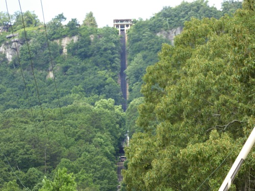
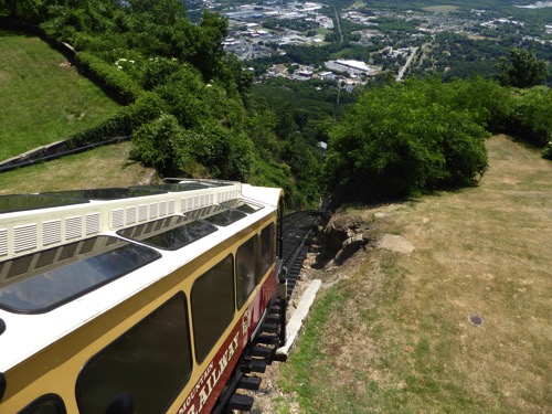
We also enjoyed the Incline Railway up to the top of Lookout Mountain. It is considered the steepest railway in the world at 72.7% grade. At the top is Point Park where we learned the most about the battles and could see not only the Chickamauga battle fields but the city itself. The park was built by the US Corps of Engineers thus they erected their symbolic gate at the entrance of the park.
Thursday, June 16, 2016
Golf, Kayak, and Thunderstorm
Tims Ford Lake
Tims Ford Lake is one of the lakes formed by a dam on the Tennessee River and the TVA or Tennessee Valley Authority. A man with the last name of Tims lived on the river near a place that was easy to cross or ford the river, thus the name Tims Ford.
We got the inflatable kayak out and went paddling a couple of times. We played golf twice on the State Park Golf Course named Bear Trace. We survived a severe thunderstorm. We drove into Winchester for lunch one day and stopped at an Amish store for eggs and butter. I did laundry, we read books, we took naps, and we researched Chattanooga, our next destination.
I’d say this was a very relaxing place to stay.